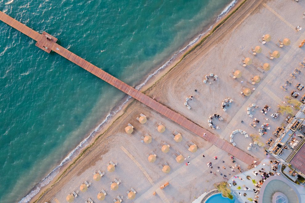
Sparta – Kalamata via Taygetos, the most beautiful mountainous route in the Peloponnese
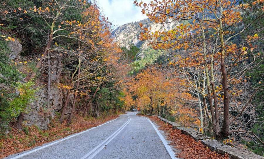
The most beautiful mountainous route in the Peloponnese starts from Sparta and leads to Kalamata (or vice versa), but not through the modern highway, instead following the old provincial road of Taygetos. The Pentadaktylos of the Byzantines and the Taleton of the ancient Greeks, reaching an altitude of 2,407 meters, is the twelfth highest mountain in Greece. It is also referred to as the “Trulos tou Moria” because it is the highest mountain in the Peloponnese. Additionally, its mountain range spans a length of 115 kilometers. Due to its massive volume, it extends across three regions: Arcadia, Laconia, and Messenia. Knowing the imposing Mount Taygetos There are many ways for someone to experience this imposing mountain in the southern part of the country. From beautiful villages and monasteries perched on its slopes to paths that traverse a spectacularly large portion of the mountain, canyons, and valleys. However, the easiest way for someone to witness the magnificence of nature unfolding before their eyes is to take their car and make the journey from Sparta to Kalamata via the old road that connected these two cities. A route particularly beloved by those who crossed it, filled with many memories. A few years ago, before the new highway was opened to traffic, to reach Kalamata from Sparta (or vice versa), one had to climb Mount Taygetos. Either by following the classic winding route from the tourist kiosk or through Megalopolis. The most impressive route in the Peloponnese. Certainly, the most impressive route is the one that starts from Sparta, ascends to Trypi, and the renowned Keadas, and from there, following the ribbons, begins to climb the mountain, crossing the wild gorge of Lagkadas. The altitude difference between Sparta and the tourist kiosk is almost 1,100 meters. This means that until we reach the tourist kiosk, where there is a cafe and a restaurant, we have only uphill terrain ahead of us. However, the route is adorned with breathtaking scenery. Moving along the edge of the cliff, you’ll need to enter tunnels within the rocks, climb onto “balconies” of cliffs, and traverse areas literally covered by plane trees. Our only companions are some other adventurous drivers and occasionally wild goats and wild boars, adding a touch of romance to the journey. The scenery is dreamlike throughout all seasons of the year. But if you happen to pass through during the autumn months, then a fairytale landscape in golden, orange, and red hues will enchant you! If you find a place to park, then get out and admire the beautiful view. You’ll feel an unprecedented sense of fulfillment within yourself, and a miracle will unfold on the wild slopes of Taygetos. Because no matter what humans create, no matter how many monuments are erected, and no matter how much art is praised, nature will always remain the one and only wonder of life. As we mentioned, the highest point of the journey is the tourist kiosk at an altitude of 1,300 meters. The temperature difference from the two cities is noticeable here, reaching up to 10 degrees Celsius. Delights from local vendors, taverns under the plane trees, and a breathtaking sunset. From the tourist kiosk onwards, we descend the mountain with an endless view between the mountains and the sea. Here, note that you can see (if you catch the right moment) one of the most spectacular sunsets, with the sun setting into the Messinian Gulf, painting the sky with intense shades of purple! Throughout this journey, you will also encounter local vendors selling their delights at makeshift stalls along the roadside. Local, pure products depending on the season, bearing the stamp and care of the region. As you rightly suspect (if you are younger) or as you correctly remember (if you are older), when this was the main artery of communication and transportation between the two cities, there was a bustling atmosphere with such vendors along the entire length of the route. Even today, here you will find the juiciest and tastiest cherries in spring, as well as the crispiest and most flavorful chestnuts in the fall. You can also purchase pure honey, fragrant tea, and other mountain herbs and spices. Descending from the side of Kalamata, you will find charming taverns in the small villages you pass through, which, if you’re hungry, will become your personal oasis. Under the colossal plane trees, you’ll taste local cheese, wild greens, fresh meats, and roasted piglet. I know that modern closed highways are comfortable, fast, and offer greater safety. However, none of them will offer you the magic of the natural wealth of a mountain. For this reason, the next time you want to travel from one city to another, think about it again!
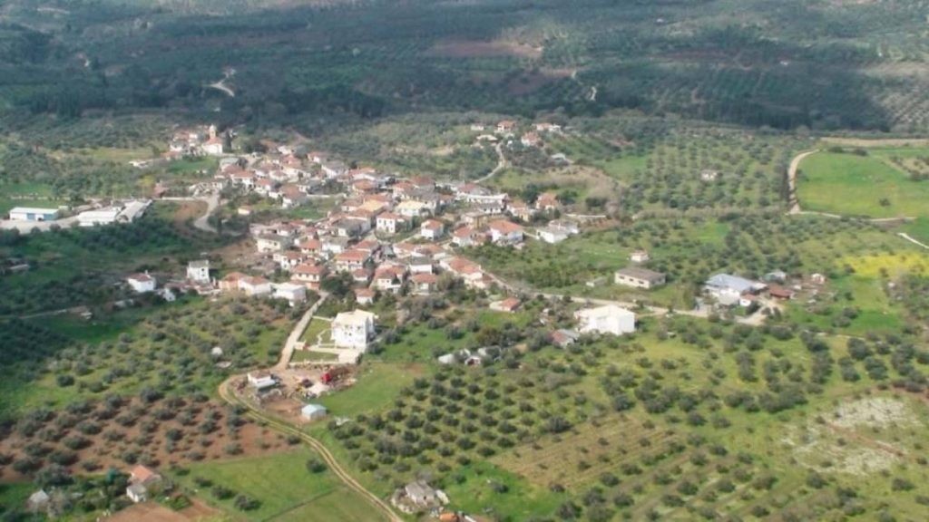
Rigklia: The mountainous village of Messinia with its two rivers and a sea view
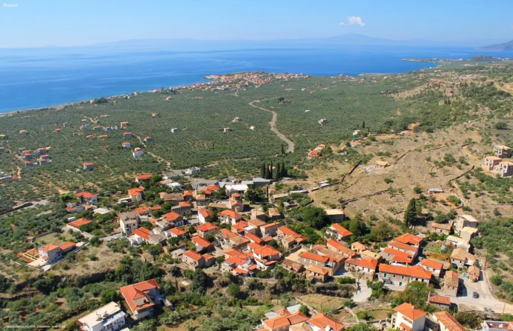
The distinctive region of Mani has gained considerable recognition in recent years, thanks to travel reports. However, this has predominantly favored its coastal areas, boosting tourism during the summer season. The more mountainous sections, therefore, continue to hold surprises for those inclined towards more thorough explorations in different seasons of the year. One such mountainous gem in Messinia is the village of Rigklia, administratively part of Western Mani and located approximately 47 kilometers from Kalamata. Easy access is provided via the provincial road connecting Kalamata to Areopoli. Expect to arrive in about 1 hour, making the area ideal for planning a delightful day trip. Rigklia is situated at an altitude of 120 meters on the southwest slopes of Mount Taygetos, with a total population of 213 residents according to the 2011 census. The use of ‘total’ population is significant, indicating that the community has preserved its traditional characteristics, still consisting of three more or less distinct settlements. Characteristic cobblestone alley of the village, nestled among traditional stone-built houses. Photo: Municipality of Western Mani. What is worth seeing if you come to Rigklia. Characterized by the mountainous side of Messinian Mani, Rigklia is situated on a beautiful plateau adorned with olive groves (and some cypresses), built on a strip of land between two rivers flowing from the neighboring Mount Mela (part of Taygetos). The landscape gains even more idyllic charm with the stunning view that the village enjoys towards the Messinian Gulf. During the summer, the two rivers tend to dry up completely, but regain water when the rains begin. Rigklia is not a medieval village but rather a creation of the later years of Ottoman rule in the Peloponnese. It is estimated that it took its current form around 1800 when the families of Gennimatas, Christeas, and Kyvaleas settled in the area. However, the initial settlement seems to be even older, as an inscription from 1737 is preserved in a house. Originally spelled as ‘Rigglia,’ the spelling was simplified in 1920. Until 1938, they were considered part of Laconia; however, since then, they have definitively belonged to the Messinian territory. Rigklia is located on a plateau in Messinian Mani, surrounded by olive groves and some cypresses. Photo: Wikipedia Creative Commons. The aforementioned arrival of the three families is likely behind the trilateral division of the community, which, as mentioned earlier, still persists to this day. Upon visiting, you will see the village articulated into Ano Rigklia, Kato Rigklia, and Eleochorio (also known as Izina). Taking a stroll through the cobblestone streets, you will encounter various fountains, traditional stone-built houses in the three settlements—some dating back to the pre-revolutionary period—and numerous Byzantine-era churches. Some of these churches are considered today as preserved monuments, serving as attractions for the village. For instance, the church of the Dormition of the Theotokos in Ano Rigklia or that of Saint George in the same area. The latter is noteworthy for its tiled roof and stands out for its bell tower as well as its wall paintings, exemplifying folk art from the second half of the 18th century. The Temple of the Transfiguration of the Saviour has been standing in the village since 1854, serving as the focal point for the annual festival. Photo: Wikipedia Creative Commons. In Kato Rigklia, on the other hand, stands the Transfiguration of the Saviour, constructed in 1854. Today, it serves as the focal point for a grand local festival held on August 6. Here, you will also find a distinctive stone-built well, covered by an arch, reflecting an old everyday life. Finally, concerning attractions, it’s worth venturing a bit outside the village to see the Church of Agia Paraskevi: built inside a cave on a rugged slope, it offers unparalleled views of the Messinian Gulf. The arched-roof well in Kato Rigklia. Photo: Wikipedia Creative Commons. Accommodation – Coffee – Food “Despite their small size, Rigklia has not overlooked the development of tourism in Messinian Mani. Therefore, if you’re not just passing through for a day trip but wish to stay, you’ll find various accommodation options—both within the village and in the surrounding countryside. For example, you can check out the ‘Riglia Residence,’ operating as a hotel in a luxurious, stone-built villa in the center of the settlement. As for coffee and food, on the other hand, you will need a car to travel to the coastal front. Within less than 2 kilometers, the picturesque fishing village of Agios Nikolaos is a well-developed destination and traditionally serves as a ‘taverna’ for both Rigklia and the broader mountainous area.”
What does it mean to be from Kalamata
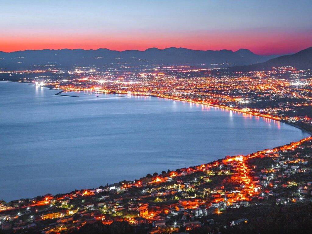
We have written many times about Kalamata and its beauties! Now it’s time to talk about its residents and why they should be proud of their hometown! Reading the following sentences, those from Kalamata will surely agree with most, if not all! Below is a list of 26 of the countless reasons why we love Kalamata: Because from Kalamata, the Revolution of 1821 started, gifting the greatest treasure to all Greeks, our freedom! Because Kalamata combines mountains and sea harmoniously. Because even if you’re not from Kalamata, you’ll still dance the Kalamatian dance! Because we all know what to do in an earthquake… from experience! Because we are known from the Homeric times as Pharae. Because you can attend the International Dance Festival at the beginning of every summer. Because you don’t need to leave to go on vacation! Because you can admire the stunning view of the city and the sunset from the shops in the Verga area. Because Kalamata has the Mavri Thiella (Black Storm) the football team of the city! Because the great musician Yanni is inspired by the city where he was born. Because Kalamata has both a White Night (When the shops remain open all night.) and its own Carnival! Because you can taste many traditional products such as pasteli, spoon sweets, lalangia, Kalamata olives, figs (tsapelas), and excellent fig pies! Because Kalamata produces the best olive oil globally. Because Kalamatians grew up in silk (Kalamatian Scarf). Because we say ‘Mama’ at least ten times a day. Because in Kalamata, we speak with both ν (ni) and λ (li)! Because from Friday night in the square, everyone has a story or two to share! Because we have Panagia Ypapanti, our protector and patron saint. Because the beautiful chapel of the Holy Apostles carries a great heritage. Because the hidden shops in the Historic Center are impressive. Because the Messinian Gulf still has crystal-clear and azure waters. “Because you will ‘drink’ us even on the other side of the world! Because Kalamata women are among the most beautiful in Greece… Because you must have “timoni kalamatiano” (Kalamatian ship’s helmsman), as sung by Zampetas. And in the end, because being a KALAMATIAN is not something you become… you are born one!
Το βραβευμένο υπαίθριο μουσείο τρένων της Ελλάδας βρίσκεται στην Καλαμάτα
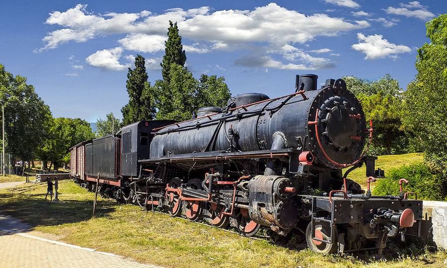
Στο Δημοτικό Πάρκο Σιδηροδρόμων που βρίσκεται στην Καλαμάτα λειτουργεί το μοναδικό στο είδος του βραβευμένο υπαίθριο μουσείο τρένων της Ελλάδας. Το πρωτοποριακό υπαίθριο μουσείο της Μεσσηνίας ήταν το πρώτο θεματικό πάρκο στην Ελλάδα κι έχει βραβευτεί από την Ευρωπαϊκή Ένωση. Λειτούργησε το 1990 και όλο το υλικό της έκθεσης καθώς επίσης και μέρος της έκτασης που καταλαμβάνει το πάρκο, έχει παραχωρηθεί από το δίκτυο του ΟΣΕ Πελοποννήσου και Θεσσαλίας. Μπορεί σε διάφορες πόλεις της Ελλάδας που έχουν πάψει να λειτουργούν οι σιδηρόδρομοι να έχουν «ξεμείνει» κάποιες μηχανές τρένων ή κάποια βαγόνια στους σταθμούς αλλά πουθενά δεν υπάρχει τέτοια έκταση με τόσο πολλά εκθέματα από εκείνη την εποχή. Φτάνοντας εδώ ο επισκέπτης, το μόνο που έχει να κάνει για να μεταφερθεί σε εκείνη τη μακρινή και ρομαντική εποχή που τα τρένα αποτελούσαν βασικό τρόπο μετακίνησης, είναι απλώς να διαβεί την πύλη. Η είσοδος είναι δωρεάν και εντός του πάρκου εκτός από τα εκθέματα των τρένων λειτουργεί καφέ – αναψυκτήριο το οποίο στεγάζεται στο παλιό σταθμαρχείο. Ελάχιστα αρχιτεκτονικά στοιχεία έχουν αλλάξει από την εποχή που εδώ χτυπούσε η καρδιά του σιδηροδρομικού σταθμού της Μεσσηνίας κι αυτό προσδίδει μια αρχοντιά και μια σπάνια φινέτσα στο χώρο. Διασχίζοντας λοιπόν την καταπράσινη έκταση του πάρκου η οποία καταλαμβάνει 54 στρέμματα (μια αληθινή όαση μέσα σε μια πόλη!) θα βρεις παιδικές χαρές, γήπεδα μπάσκετ και βόλεϊ, ποδηλατοδρόμο και τη μεγάλη πεζογέφυρα μήκους 28 μέτρων. Αξίζει να σταθείς σε κάθε βαγόνι και μηχανή ξεχωριστά και να αφιερώσεις λίγο χρόνο. Υπάρχουν τρένα τα οποία λειτουργούσαν σαν εμπορικά ή σαν επιβατικά Α και Β θέσης και άλλα που μετέφεραν ογκώδη εμπορεύματα. Εντυπωσιακές είναι οι πλατφόρμες και τα διώροφα φορτηγά καθώς επίσης και ο χειροκίνητος γερανός του 1890 που βρίσκεται μπροστά από το παλιό σταθμαρχείο και νυν καφενείο. Ανάμεσα στις ατμάμαξες που θα δεις, υπάρχει και μια πραγματικά τεράστια η οποία μετράει 28 μέτρα. Μερικά βαγόνια μπορεί να τα θυμάσαι αν ποτέ τα είχες χρησιμοποιήσει σε κάποιο δρομολόγιο των ιστορικών διαδρομών της Πελοποννήσου ή της υπόλοιπης Ελλάδας. Υπάρχουν όμως κι εκθέματα τα οποία χρονολογούνται από τον προπερασμένο αιώνα. Μπορεί πλέον οι μετακινήσεις με το συγκεκριμένο μέσο, να μην είναι τόσο συχνές όπως συνέβαινε τον προηγούμενο αιώνα, τα τρένα όμως αποτελούν ένα πολύ ιδιαίτερο κομμάτι της Ελλάδας αφού οι αμαξοστοιχίες κυριάρχησαν για πολλά χρόνια καθιστώντας τις μετακινήσεις εύκολες και οικονομικές. Ο Χαρίλαος Τρικούπης θεωρείται ο πατέρας του σιδηροδρομικού δικτύου στην Ελλάδα. Ήταν εκείνος που οραματίστηκε μια «ενωμένη» με ράγες χώρα και εν υπηρεσία της κυβέρνησής του κατασκευάστηκε σχεδόν ολόκληρο το σιδηροδρομικό δίκτυο της χώρας, όπως το ξέρουμε σήμερα. Αν δεν είχαν αντιμετωπιστεί σοβαρά οικονομικά προβλήματα που οδήγησαν στην πτώχευση του 1893, ίσως να είχαν κατασκευαστεί κι άλλες γραμμές. Παρόλο που σε ολόκληρο τον πλανήτη οι συγκοινωνίες με τρένο συγκαταλέγονταν πάντα στις πρώτες θέσεις προτιμήσεων των πολιτών, στην Ελλάδα δε συνέβη ποτέ αυτό. Τα τρένα αποτελούσαν ίσως μια δεύτερης κατηγορίας τρόπο μετακινήσεων αν και οι διαδρομές τους ήταν τουλάχιστον εντυπωσιακές διανύοντας υπέροχα ορεινά, πεδινά και παραθαλάσσια τοπία. Μερικές γραμμές είναι τόσο χαρακτηριστικές που ακόμη κι αν λειτουργούν πια μόνο για τουριστικούς λόγους, αποτελούν ολόκληρες ατραξιόν νομών. Χαρακτηριστικό παράδειγμα είναι ο διάσημος Οδοντωτός που συνδέει τα Καλάβρυτα με το Διακοπτό. Διαδρομή που έχει χαρακτηριστεί σαν η πιο εντυπωσιακή των Βαλκανίων. Αν βέβαια θέλουμε να το πιάσουμε από την αρχαιότητα, τότε θα δούμε ότι η Δίολκος στην Αρχαία Κόρινθο αποτελούσε μια μορφή σιδηρόδρομου χωρίς ράγες. Μέσω αυτής της γραμμής στη στεριά, οι Κορίνθιοι οι οποίοι έλεγχαν το εμπόριο της περιοχής, «περνούσαν» τα πλοία από τον Κορινθιακό στο Σαρωνικό κόλπο (και αντίθετα), γλιτώνοντας έτσι το πολυήμερο κι επικίνδυνο ταξίδι του γύρου της Πελοποννήσου. πηγή: mesogeiosv.gr
Kardamili: The ‘Wanderer’ of the Peloponnese
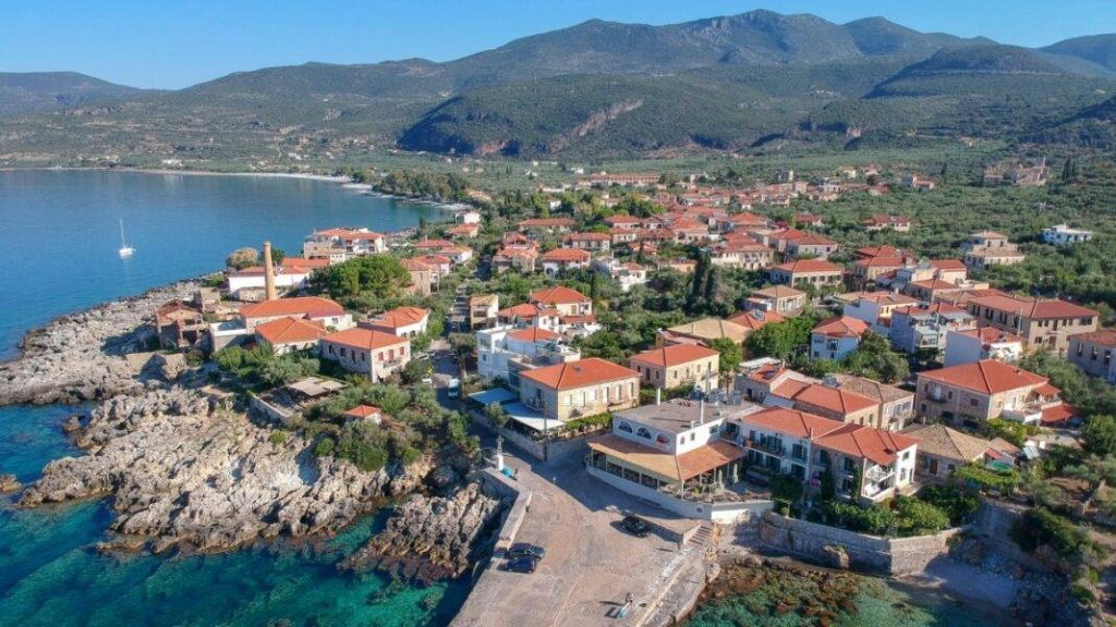
“Kardamili: The Largest Village of Messinian Mani, A Historic Gem of Unparalleled Beauty and Charm, Featured in Hollywood Films, and a Residence for Many Celebrities… The ‘Wanderer’ of the Peloponnese Always an Ideal Destination for Excursions!” “This is a traditional stone-built village in the Peloponnese, one of the most beautiful villages in Greece, nestled in a windless cove opposite the lush islet of Meropi. To this day, the ruins of Venetian walls and the church of Saint John remain preserved on the island. On one side, it is bathed by the Messinian Gulf, while on the other, it leans against the slopes of Mount Taygetos.” Historic Village The history of Kardamili dates back to the time of Homer and the Iliad. The poet mentions that Kardamili was one of the seven cities Agamemnon offered to Achilles as a dowry if he married one of his daughters. Later, it was named ‘Skardamoula,’ and in recent years, the ancient name prevailed once again. Kardamili became a refuge for refugees from Mystras after its destruction in 1460. They sought shelter in caves, which is why they were called the ‘Troupakides.’ In Kardamili, Theodoros Kolokotronis and the Maniot leaders planned the 1821 revolution. The Old Kardamili The Old Kardamili is perched on the mountainside above the newer coastal settlement and stands as a unique attraction in the region. Its characteristic features include the tower houses built around the 18th-century church of Saint Spyridon, adorned with double-headed eagles from the Byzantine era, and the preserved buildings constructed 200 or even 300 years ago. The entire region belonged to the renowned family of ship captains, the Mourtzinos-Troupakides, descendants of the Palaiologos, who were the rival power to the Mavromichalis in the domination of Mani. Scattered across the surrounding hills, one can find Byzantine and post-Byzantine chapels such as the monasteries of Agia Sophia, Karaveli, and Faneromeni. The Old Kardamili has a rich history and played a significant role in the liberation struggle against the Turks. On the castle gate, there is a marble inscription: ‘On January 6, I came to the house of my paternal friend Captain Panagiotis Troupakis,’ from Kolokotronis’s memoirs. Following the path from the Old Kardamili to Agia Sophia, one can visit the sculpted tombs on the rock, which tradition says belong to the Dioscuri, the mythical children of the Spartan queen Leda. New Kardamili The new settlement is a lively resort filled with people, featuring mansions, lush slopes, and pebbly beaches. It boasts excellent tourist infrastructure, local taverns serving specialties, and atmospheric bars. Many visitors, including artists, actors, and notable figures like Mariza Koch and the renowned British author Sir Patrick Leigh Fermor, have chosen Kardamili as their permanent residence. The picturesque stone backdrop of Kardamili has also attracted the bright lights of Hollywood. American filmmakers chose Kardamili as a natural setting for the movie ‘Before Midnight’ starring Ethan Hawke and Julie Delpy, which was shot in the area two years ago. During the winter, you can enjoy the eerie landscape here and explore the region’s beauty, which takes on a different color, while in the summer, the beaches of the area take center stage. One of the most famous beaches in Kardamili is Ritsa. Further north, in the location of Langadakia, you’ll find Porto Gatea, a rocky promontory with a beach full of salt pans. Very close to Kardamili is the beach of Kalimitsi, surrounded by tall cypress trees and shallow, crystal-clear waters. Right after Kalimitsi, you’ll find the popular Fonias beach, with pebbles, deep waters, and the characteristic rock perfect for diving. πηγή: travelstyle.gr
Kremmydia: The Village That Made It into the “Guinness World Records Book”
The small village of Kremmydia, located in Messinia, has managed to make an impressive entry into the Guinness World Records. Despite the fact that the primary occupation of its residents was agriculture, this did not prevent them from investing in education. In the year 2000, Kremmydia was registered in the Guinness World Records as the village with the highest percentage of science graduates in its total population. According to the report in the Guinness World Records, the percentage of scientists in relation to the community’s total population was around 30%, meaning approximately one in three residents held a degree in a scientific field. However, with the decrease in population, things have changed significantly. The village’s sole primary school, where many of these scientists studied, has closed due to a lack of students.
Koroni: The city of Messinia also known as the “Princess of the Middle Ages”
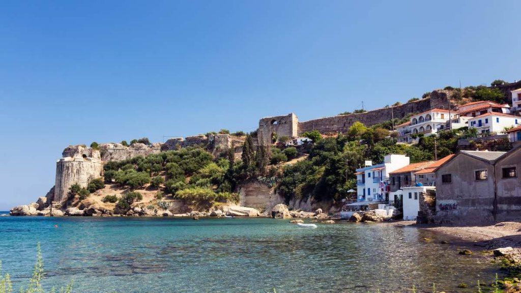
At the southernmost tip of Messinia, at Cape Akrita, is the cosmopolitan Koroni. One of the most beautiful and well-known coastal towns of the Peloponnese, which is built amphitheatrically on the slope of a hill, where the Venetian fortress dominates. It is no coincidence that the nickname of this small town with a long history is “Princess of the Middle Ages”. Koroni Built amphitheatrically on the western coastline of the Messinian gulf, Koroni, the once famous Castle City of Messinia, is a residential complex of exceptional beauty, with a strong island color. Like its neighbor Methoni, Koroni experienced a period of prosperity during the Medieval Times, when it developed into a notable commercial and naval center for the Venetians, a regular stop for merchants, pilgrims to the Holy Land and Mediterranean travelers. Often, in fact, these two important Messinian ports were referred to together as “Mothokorona”. A dominant position in Koroni is occupied by its castle, which was built during Byzantine times (probably in the 6th-7th century) where, according to Pausanias, the city of Asini used to be. The original Byzantine fortification experienced successive building phases during the First Venetian period (13th-15th century) with the addition of a large enclosure to the east, strong walls and a double semi-circular bastion in the north-east corner, for protection from the sea side. The castle of Koroni was captured by the Turks in 1500. During the First Ottoman Empire (1500-1685) the fortification of the castle was strengthened on the southeast side with a second line of defense and the addition of two circular bastions at its ends. The castle was recaptured by the Venetians in 1685 (2nd Venetian Empire), it fell again to the Turks in 1715 (2nd Turkish Empire), and was liberated in 1828 by the French general Nicolas Joseph Mezon. The Castle of Koroni was built during Byzantine times, on the site where the ancient city of Asini once dominated. The castle of Koroni can be reached by car, crossing the road that starts from the terrace of Agios Dimitrios. The castle of Koroni together with its brother, that of Methoni, were “The eyes of Venice” in the Mediterranean, as from the 13th to the 17th century they were ports – “keys” for trade from and to the East. The castle attracts the eye like a magnet. It’s beautiful!When you visit it, we advise you to spend a few minutes enjoying the view it offers. A few words about its history The Castle experienced various building phases per time period. Initially, it was distinguished in a triangular area and an external fortification to the east. The Byzantine fortress was located at the highest point, where the nunnery is today. During the 1st Venetian rule, a large precinct was added to the east, strong walls and the double semi-circular bastion were built in the north-east corner, for the purpose of protection from the sea side. In the First Ottoman period the fortification was strengthened on the south-eastern side with a second line of defence, which was blown up by Morosini in 1685, and the addition of two circular bastions at its ends. At the end of World War II, the bastion at the northern end of the wall was blown up by the Germans. Today, few ruins of this particular part of the Castle are preserved. In 1463, at its westernmost edge, the Venetians built a rampart, which experienced successive building phases, with the last being that of the Second Venetian Empire (1685-1715). Inside the castle are preserved the remains of the three-aisled basilica of Agia Sophia (probably from the 7th century) and the church of Agios Charalambos (the original Catholic church, dedicated to Agios Rocco, was converted into an Ottoman mosque and then, in modern times, into an Orthodox temple). During the additions, ancient building material was used. Within the walls of the castle is also the monastery of Timi Prodromos, with a wonderful view of the modern town. The monastery was founded at the beginning of the 20th century by Archimandrite Theodoulos (Georgio Anagnostopoulos). At the western end of the Castle there is the old calendar monastery (Monastery of the Holy Forerunner) which was founded at the beginning of the 20th century.
The small village of Messinia, which is a green paradise with amazing waterfalls
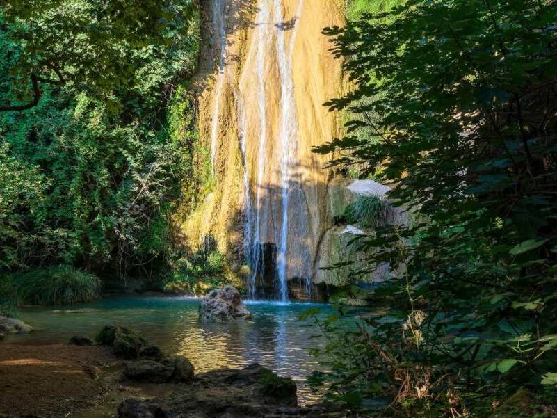
One of the most beautiful Greek villages, it is located near Pylos, from which it is about 11.5 kilometers away and is built at an altitude of 177 meters. Stenosia, the village of Messinia that stands out for its amazing waterfalls, which become a magnet for visitors just like the entire surrounding landscape. The village has a long history in Messinia, being part of the kingdom of Nestor, ancient Pylos. The settlement was known as Lezagas and from 1940 until today as Stenosia. Based on the 2011 census, it has 446 permanent residents, who are mainly engaged in agricultural work and trade. The amazingly beautiful waterfalls Stenosia is a welcoming village and at the same time an ideal destination for lovers of alternative tourism, while it can be an oasis of coolness and an occasion for family escapes, as the landscapes all around are beautiful. Starting with its unique waterfalls that become a magnet for visitors in all seasons of the year, the village is a small green paradise. In fact, just outside the village there is a green gorge crossed by a calm river, with small waterfalls and ponds. Its total length is 3-4 kilometers and ends at the well-known Kalamari waterfall of Pylia. In addition to its unique natural environment, it is of particular value to note that there the Italians built a dam and created the first hydroelectric station in Messinia that supplied electricity to Pylos. The wonderful waterfalls of the river Neda The river Neda originates from Mount Lykaios, on the border of the prefectures of Ilia and Messinia. As Pausanias mentions, Neda defined the borders of the two prefectures since ancient times. It empties into the Ionian Sea, between the coasts of Kyparissia and Zacharos. The river in a large part of it crosses a ravine with very rich vegetation. Waterfalls are created along its course. The largest is located near Figalia and is about 50 meters high. Watch the amazing video of the waterfall: πηγή: travelstyle.gr
W Costa Navarino: The first worldwide to be certified by the International LGBTQ+ Travel Association
Costa Navarino is committed to applying the principles of inclusive hospitality so that everyone who visits the destination feels truly welcome. Embracing uniqueness, Costa Navarino launched a route a year ago, with a series of actions, to create the conditions to understand the needs of different travel audiences, so that everyone feels safe and comfortable. As a result of these efforts, W Costa Navarino, which opened last year, is the first hotel in the world to be certified by the International LGBTQ+ Travel Association (IGLTA), for the inclusive hospitality practices it has adopted. IGLTA Accredited™ is a new program that ensures travel brands are committed to promoting equality and safety for LGBTQ+ travelers. For a brand to be recognized as IGTLA Accredited™, travel agencies, as well as hotels, must meet eight strict criteria, which are certified through assessment. “Costa Navarino’s philosophy is based on respect for our guests. We are committed not only to meet their expectations, but to exceed them”, said Stefanos Theodoridis, CEO of TEMES. “Recognizing the unique personality of each person, our aim is to anticipate the different needs, so that each person feels comfortable during their vacation. The fact that W Costa Navarino is the first hotel in the world to receive the IGLTA Accredited™ distinction is a great honor and shows us that we are on the right track,” he added. Within the framework of the actions that have been implemented in the last year, is the collaboration with organizations such as the University of Piraeus, HospitableMe – a leading company in inclusive hospitality – and IGLTA, to conduct research and understand the needs of different groups and how the tourist can industry to respond to them. Based on the results obtained, Costa Navarino implemented a number of practices to recognize the preferences of visitors according to their culture, racial identity, religion, or according to the visual, hearing, mobility difficulties they may face or be on the spectrum of autism etc. The first steps have been taken, but the journey to a fully inclusive destination continues. W Costa Navarino: Το πρώτο παγκοσμίως που πιστοποιείται από το International LGBTQ+ Travel Association – ΕΦΗΜΕΡΙΔΑ ΘΑΡΡΟΣ (tharrosnews.gr)
Charakopio
# DESTINATIONS Its name means “the village of joy” and it is a picturesque village located about 5 km from Koroni. Harakopio is known for its idyllic location and the wonderful natural beauty of its area. Visitors have the opportunity to enjoy a stunning view towards the Messinian gulf, with green hills, olive groves and vineyards surrounding the village. The architecture of Harakopi exudes a traditional cheerful spirit. The stone houses with the ceramic roofs, the alleys and the squares offer a charming atmosphere. The narrow streets and buildings of the village retain their traditional characteristics. The inhabitants of Harakopi are hospitable and take care to keep local traditions alive. Hot Spots The village marketThe Cultural Association of HarakopiThe Traditional Olive Mill Museum Beaches Agia Triada BeachGargaros BeachZaga BeachMemi BeachPeroulia Beach Where are we going to eat? In the taverns of the village. Every Sunday you will also find traditional pork. Beaches in the area Παραλία Αγία Τριάδα Ή αλλιώς Λαχανού, πρόκειται για μια υπέροχη παραλία 3,5 χιλιόμετρα… Παραλία Γαργαρού Πολύ κοντά στο χωριό Χαροκοπιό, θα συναντήσετε την Γαργαρού. Μια… Παραλία Μεμί Ακόμη μια παραλία που βρίσκεται πολύ κοντά στην Κορώνη. Η… Παραλία Περούλια Μια χρυσή άμμος 1,5 περίπου χιλιομέτρου, υπέροχα νερά, πυκνή βλάστηση…